


EDWARDSVILLE 20 Voting District, Madison County, Illinois
About
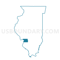
Outline

Summary
| Unique Area Identifier | 573419 |
| Name | EDWARDSVILLE 20 Voting District |
| County | Madison County |
| State | Illinois |
| Area (square miles) | 1.24 |
| Land Area (square miles) | 1.21 |
| Water Area (square miles) | 0.02 |
| % of Land Area | 97.99 |
| % of Water Area | 2.01 |
| Latitude of the Internal Point | 38.76731710 |
| Longtitude of the Internal Point | -89.98940100 |
Maps


Graphs
Select a template below for downloading or customizing gragh for EDWARDSVILLE 20 Voting District, Madison County, Illinois


Neighbors
Neighoring Voting District (by Name) Neighboring Voting District on the Map
- EDWARDSVILLE 18 Voting District, Madison County, IL
- EDWARDSVILLE 22 Voting District, Madison County, IL
- EDWARDSVILLE 24 Voting District, Madison County, IL
- EDWARDSVILLE 25 Voting District, Madison County, IL
- EDWARDSVILLE 26 Voting District, Madison County, IL